Abelian
Solar siting.
Hazard risk.
Trade areas.
Analyzed and auditable.
Three spatial analysis modules built on shared infrastructure. 34 federal data sources with adaptive confidence scoring.
What it looks like
Three analysis modules
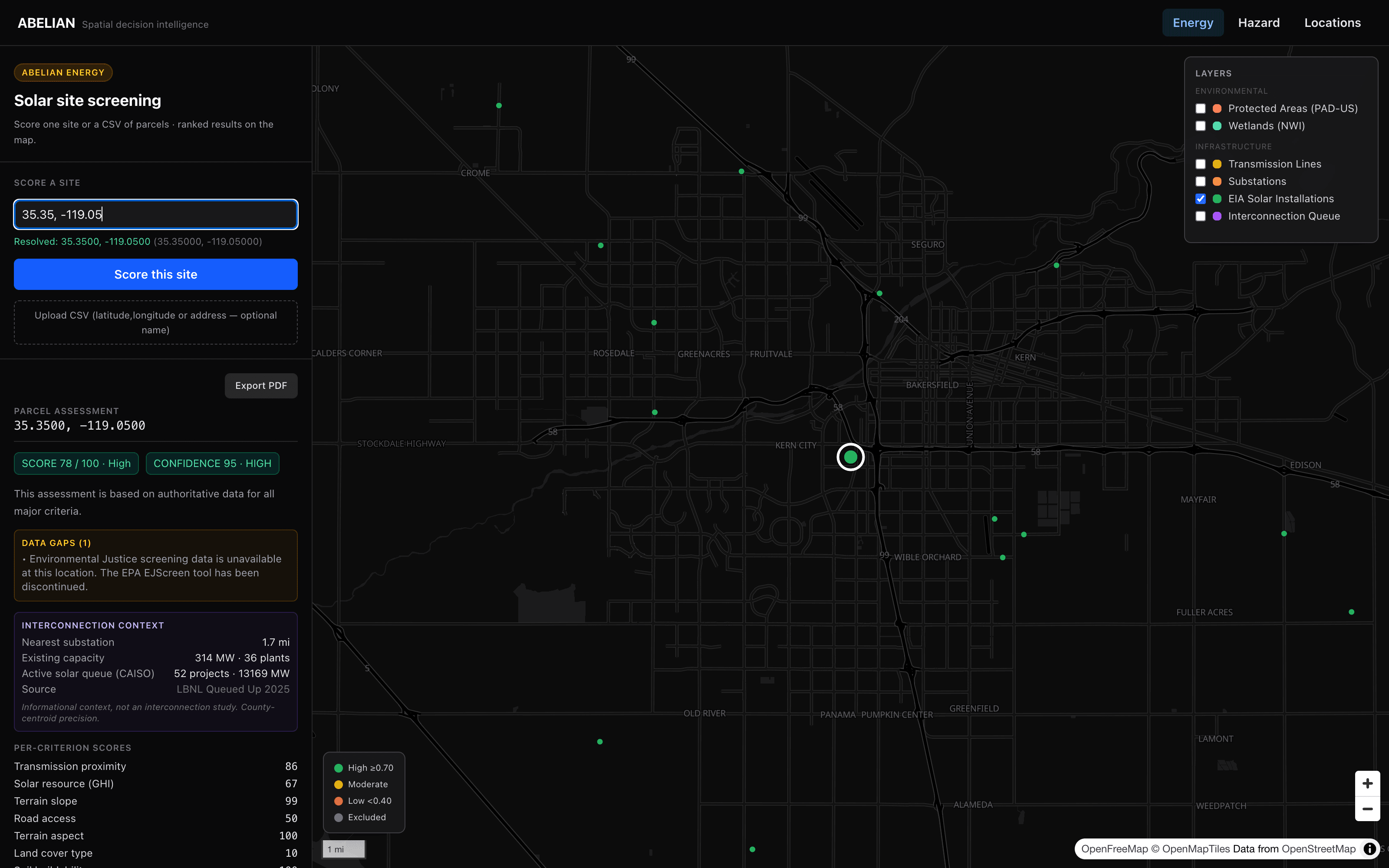
Abelian Energy
Solar site screening
14 criteria · regional weight calibration · 6,321 EIA installations
Validated: 71% High across 10 states
Try it →Abelian Hazard
Wildfire + flood risk
10 criteria · per-peril dollar estimates · NSI building data
Validated: AUC 0.76 (Sonoma), 16x discrimination (Lee County)
Try it →Abelian Locations
Trade area analysis
7 criteria · Huff gravity model · drive-time isochrones
Validated: 96.7% Starbucks Strong (Dallas)
Try it →How it works
Data Repository
34 sources
Federal and open data with availability checking per location.
Methodology Repository
31 criteria
Data trees and academic citations. Doorga, Hernandez, Huff, Scawthorn, Finney.
Data Selection Engine
Quality-ordered
Traverses trees per criterion. Selects the best source at each location: authoritative → fallback → proxy → gap.
Confidence Scoring
Five tiers
Reports what data was used, where gaps are, and how much to trust the result. HIGH to CANNOT ASSESS.
Adaptive data selection
Wetlands criterion
National Wetlands Inventory loaded for Kern County
Status: Available at this location
National NWI service (currently degraded)
Status: Would try if PostGIS unavailable
Soil-based wetland indicator from USDA
Status: Fallback used outside loaded geographies
At each location, the engine tries the highest-quality source first. If unavailable, it falls back and reports reduced confidence. Outside Kern County, wetlands data falls back to the SSURGO soil proxy. The output tells you exactly which source was used.
What the API returns
{
  "location": { "latitude": 35.35, "longitude": -119.05 },
  "score": 78,
  "rating": "High",
  "weight_profile": "WECC (calibrated)",
  "confidence": {
    "tier": "HIGH",
    "composite": 0.95,
    "statement": "Based on authoritative data for all major criteria."
  },
  "criteria": {
    "Transmission proximity": { "score": 86, "source": "HIFLD Transmission Lines", "confidence": "HIGH" },
    "Solar resource (GHI)": { "score": 67, "source": "NREL PVWatts v8", "confidence": "HIGH" },
    "Terrain slope": { "score": 99, "source": "USGS 3D Elevation Program", "confidence": "HIGH" },
    "Road access": { "score": 50, "source": "OpenStreetMap Roads", "confidence": "HIGH" },
    "Terrain aspect": { "score": 100, "source": "USGS 3D Elevation Program", "confidence": "HIGH" },
    "Land cover type": { "score": 10, "source": "National Land Cover Database", "confidence": "HIGH" },
    "Soil buildability": { "score": 100, "source": "USDA SSURGO", "confidence": "HIGH" }
  },
  "exclusions": {
    "Protected areas": { "result": "pass", "source": "USGS PAD-US" },
    "Wetlands": { "result": "pass", "source": "National Wetlands Inventory" },
    "Critical habitat": { "result": "pass", "source": "USFWS" },
    "Steep slope": { "result": "pass", "source": "USGS 3DEP" },
    "Developed land": { "result": "pass", "source": "NLCD 2021" }
  },
  "gaps": [
    { "criterion": "Environmental Justice", "message": "EPA EJScreen discontinued." }
  ],
  "interconnection": {
    "nearest_substation_mi": 1.7,
    "existing_capacity_mw": 314,
    "queue_projects": 52,
    "queue_capacity_mw": 13169,
    "iso": "CAISO"
  }
}
Every assessment returns the score, the data source for each criterion, the confidence level, and where the gaps are.
10-state solar validation
| State | NERC | EIA %High | Random %High | Separation |
|---|---|---|---|---|
| Texas | ERCOT | 87% | 47% | +0.079 |
| Arizona | WECC | 40% | 33% | +0.220 |
| North Carolina | SERC | 53% | 40% | +0.044 |
| Nevada | WECC | 47% | 7% | +0.204 |
| Florida | SERC | 53% | 0% | +0.184 |
| California | WECC | 53% | 33% | +0.118 |
| Georgia | SERC | 47% | 20% | +0.104 |
| Colorado | WECC | 73% | 40% | +0.190 |
| Indiana | MISO | 40% | 20% | +0.062 |
| Ohio | PJM | 20% | 33% | +0.017 |
300 locations (150 real EIA installations + 150 matched random rural). 71% of greenfield-eligible installations score High. Positive discrimination in all 10 states.
34 federal and open data sources
Solar Resource
Terrain
Infrastructure
Environmental
Land & Soil
Hazard
Demographics
POIs
Interconnection